

The Best Lake Tahoe Hiking Trails: The Top 10 Trails in Lake Tahoe for All Skill Levels
Lake Tahoe North America
by Coco Tran
On August 11, 2023
WORDS BY Coco
is you’re visiting Lake Tahoe in Summer and are looking for the best hikes in Lake Tahoe. I’ve got a list of the best Lake tahoe hiking trails here. If you haven’t yet explored the stunning trails of Lake Tahoe, you’re missing out on some of the most breathtaking views and challenging hikes in the country. With trails that range from easy strolls to epic day trips, Lake Tahoe has something for everyone. Whether you’re a seasoned hiker or a beginner, you’ll find a trail that suits your skill level and offers stunning beauty.

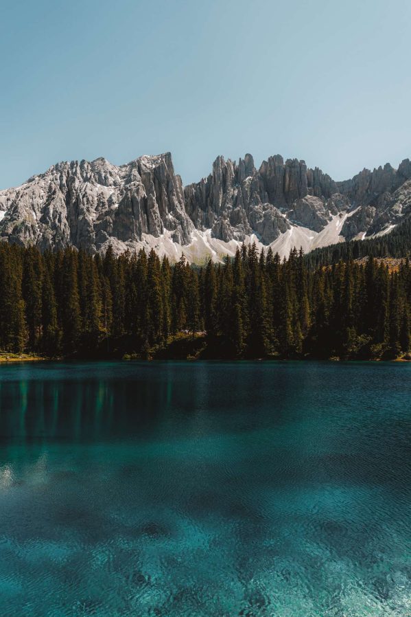
Lake Tahoe hiking trails radiate from the lake in all directions, offering you stunning beauty from every angle. You’ll find trails that take you through dense pine forests, along sparkling alpine lakes, and up to the top of granite peaks that offer sweeping views of the surrounding mountains. With so many trails to choose from, you can spend weeks exploring the area and still not see everything. Whether you’re looking for a leisurely hike or a challenging trek, Lake Tahoe has it all.
No time to read full article? This is the best hiking tour in Lake Tahoe!
READY TO BOOK YOUR TRIP?
Best Travel Resources to plan your trip
more helpful travel resources
*This site contains product affiliate links, and I may get a commission, which costs you nothing extra. Thanks for your support


In This Article: Table of Contents
some links may be affiliate links. If you purchase using the link I may get a small commission which costs you nothing extra.
South Lake Tahoe Hiking Trails
If you’re looking for some of the best hiking trails in South Lake Tahoe, you’re in luck. From easy walks to challenging hikes, there are options for all skill levels. Here are some of the top South Lake Tahoe hiking trails to check out:
DL Bliss State Park (Rubicon West Shore)
Distance: 16.4 miles roundtrip
Elevation gain: 2306 feet
Difficulty: Moderate
is Mount Tallac Trail Dog friendly?: No
If you only have time for one hike in Lake Tahoe. This is the hike to go on! This is one of the rare trails that goes along the edge of Lake Tahoe. It’s on the southern side, between D.L. Bliss State Park and Emerald Bay. The trail is long, but it’s not too hard to walk, and it offers really nice views of the blue water from the steep drop along a big part of it. You can also get to some cool little swimming spots. Starting at D.L. Bliss, the trail takes you to Emerald Bay and the Vikingsholm Castle by the bay, and then goes around to Eagle Point.

How to get there: You can start the trail either at the Emerald Bay Boat-In campground on the south side or at Lester Beach at D.L. Bliss on the north side.
Emerald Bay State Park
Emerald Bay State Park is a must-visit destination for any hiker in South Lake Tahoe. The park is home to some of the most breathtaking views in the area, including the stunning Emerald Bay and Fannette Island. The Vikingsholm Trail is a popular hiking trail that takes you down to the bay and offers stunning views along the way. The trail is about 1.7 miles long and is rated as moderate.

Inspiration Point at Emerald State Park
If you don’t want to hike a distance to enjoy a view, or if you’re going with little ones, this view point is amazing to get out of the car and see. The parking lot is right there and you can admire the views from this point. the parking is $3 an hour. There are hikes in this area you can venture on but this is a quick and easy view point if you aren’t up to hike but want to see a beautiful view of Fanette island.


Fallen Leaf Lake
Fallen Leaf Lake is another beautiful destination for hiking in South Lake Tahoe. The lake is surrounded by towering mountains and lush forests, making it a great spot for nature lovers. The Fallen Leaf Lake Trail is a popular hiking trail that takes you around the lake and offers stunning views of the surrounding scenery. The trail is about 3.5 miles long and is rated as easy.
Other Lake Tahoe Articles
Mount Tallac Trail
Distance: 9.5 mi round trip
Elevation gain: 3.500 feet
Difficulty: Difficult
is Mount Tallac Trail Dog friendly?: No

For those looking for a more challenging hike, the Mount Tallac Trail is a great option. The trail takes you to the summit of Mount Tallac, which offers stunning views of Lake Tahoe from over 9,000 feet. The trail is about 10.2 miles long and is rated as difficult. It’s important to note that this hike is not for beginners and requires proper preparation and gear.
No matter what your skill level or hiking preferences are, South Lake Tahoe has something to offer. Whether you’re looking for easy walks or challenging hikes, there are plenty of options to explore the natural beauty of the area. So grab your hiking boots and hit the trails!
North Lake Tahoe Hiking Trails
If you’re looking for some of the best hiking trails in North Lake Tahoe, you’re in luck. With hundreds of miles of trails and breathtaking views, North Lake Tahoe is a hiker’s paradise. Here are a few of the top hiking trails in the area:
Tahoe Meadows Interpretive Trail
Distance: 1.3miles roundtrip
Elevation gain: 80 feet
Difficulty: easy
is Tahoe Meadows Trail Dog friendly?: Yes
 Tahoe Meadows Interpretive Trail is a great option for those looking for an easy hike. The trail is located near Mt. Rose and is just over a mile long. The trail is mostly flat and is wheelchair accessible, making it a great option for families with young children or those with mobility issues. Along the trail, you’ll find interpretive signs that provide information about the local flora and fauna.
Monkey Rock
Distance: 2.6 miles roundtrip
Elevation gain: 498 feet
Difficulty: Moderate
is monkey rock dog friendly?: Yes
This epic view is one of the most popular lake tahoe hikes. For the trail starting point. head to Tunnel Creek Cafe. The trail is just over five miles long and offers stunning views of Lake Tahoe. The trail is steep in some places, so be prepared for a workout. At the end of the trail, you’ll be perched high up with views of lake tahoe. At the top you’ll find Monkey Rock, well, the name is easy to understand why it’s called monkey rock! At the bottom of the trail, you’ll find Tunnel Creek Cafe, a great spot to grab a bite to eat and refuel after your epic hike.
No matter what your hiking level is, North Lake Tahoe has a trail for you. From easy strolls to challenging hikes, there’s something for everyone. So grab your hiking boots and hit the trails!
Lake Tahoe East Shore hiking Trails
Lake Tahoe East Shore Trail
Distance: 2.6 miles one way
Elevation gain: 144 feet
Difficulty: Easy-Moderate
is Lake Tahoe East Shore Trail dog friendly? Yes


If you’re looking for a scenic hike along Lake Tahoe’s eastern shore, the Tahoe East Shore Trail is one of the best lake tahoe hikes. This 2.6-mile point-to-point trail near Incline Village-Crystal Bay, Nevada is generally considered an easy route, taking an average of 55 minutes to complete. The East Shore trail is a paved path you can read more details about the trail here.
Cave Rock Trail
Distance: 1.6 miles roundtrip
Elevation gain: 137 feet
Difficulty: easy
Is the Cave Rock Trail Dog friendly? Yes
One popular section of the East Shore Trail is the Cave Rock Trail. This 1.6-mile out-and-back trail offers stunning views of Lake Tahoe and Cave Rock, a large granite formation that has spiritual significance to the Washoe Tribe. The trail is rated as moderate, with some steep inclines and switchbacks, but the views at the top are worth it.
Rubicon Trail
Distance: 16.4 miles roundtrip
Elevation gain: 2306 feet
Difficulty: Moderate
Is the Rubicon Trail dog friendly? No

The most popular hikes of the Lake Tahoe East Shore Trail is the Rubicon Trail. This 16.4-mile out-and-back trail is rated as moderate to difficult, with some steep inclines and rocky terrain. The trail offers breathtaking views of Emerald Bay and Cascade Lake, and passes by several secluded beaches and coves. You can park your car at the end and a second car at the beginning so you don’t have to do the roundtrip hike and just do a one way 8 mile hike.
Whether you’re looking for a leisurely stroll or a challenging hike, the East Shore Trail has something to offer. Just be sure to bring plenty of water and sunscreen, as the trail can get hot and exposed in the summer months.
Desolation Wilderness Trails
If you’re looking for a challenge and want to explore the rugged natural wonders of the Sierra Nevada, Desolation Wilderness Trails in the Lake Tahoe area is a great place to start. Covering 63,960 acres west of South Lake Tahoe and north of Highway 50 in El Dorado County, the Wilderness offers stunning alpine lakes, granite peaks, and glacially formed valleys.
Eagle Lake Trail
Distance: 2.5 miles roundtrip
Elevation gain: 459 feet
Difficulty: Moderate
Is Eagle Lake Trail Dog Friendly?Yes

One of the most popular trails in the Desolation Wilderness is the Eagle Lake Trail. This 2.5-mile trail is perfect for a day hike and offers breathtaking views of Emerald Bay and Lake Tahoe. The trailhead is located at the Eagle Falls Picnic Area, and it’s a steep climb to the top, but the views are well worth it. You’ll pass through lush forests, cross streams, and climb over boulders to reach the top. Once you arrive at Eagle Lake, you can take a dip in the crystal-clear water or have a picnic on the shore.
Cascade Falls Trail
Distance: 1.5 miles roundtrip
Elevation gain: 459 feet
Difficulty: Moderate
Is Cascade Falls Trail Dog Friendly?No
Another popular trail in the Desolation Wilderness is the Cascade Falls Trail. This 1.5-mile trail is a relatively easy hike and is perfect for families with kids or anyone looking for a shorter hike. The trailhead is located at the Bayview Trailhead parking lot, and the trail takes you through the forest and over a wooden bridge before arriving at the falls. The falls are a spectacular sight, with water cascading down over 200 feet of granite rocks.
Both of these trails require a permit, which can be obtained at any trailhead. If you plan on doing an overnight hike, you’ll need to get a permit beforehand from the Lake Tahoe Basin Management Offices. Keep in mind that the Desolation Wilderness is jointly managed by the Eldorado National Forest and Lake Tahoe Basin Management Unit, so make sure to check the specific information on fees, permits, trail information, and the zone quota before you go.

Overall, the Desolation Wilderness Trails are a must-see for anyone looking to explore the natural beauty of the Lake Tahoe area. With its stunning alpine lakes, granite peaks, and glacially formed valleys, it’s no wonder why so many hikers and outdoor enthusiasts flock to this area every year.
Hiking Tips and Precautions
When hiking in Lake Tahoe, it’s important to take precautions and be prepared for the terrain and weather conditions. Here are some tips to keep in mind:
- Check the weather forecast before heading out on a hike, and be prepared for sudden changes in weather, especially in the mountains.
- Bring plenty of water and snacks to keep your energy levels up during the hike.
- Wear appropriate footwear with good traction, as some trails can be rocky and slippery.
- Dress in layers, as temperatures can change quickly with elevation gain or loss.
- Apply sunscreen and insect repellent to protect your skin from the sun and bugs.
- Always let someone know where you’re going and when you expect to return.
- Stay on designated trails to avoid damaging the natural environment and to prevent getting lost.
In addition to these general tips, here are some specific precautions to keep in mind for hiking in Lake Tahoe:
- Be aware of the elevation gain on the trail, as some hikes can be quite steep and challenging.
- Check if the trailhead has parking available and if there are any road closures or restrictions in the area.
- If you’re new to hiking, start with easy hikes and gradually work your way up to more challenging ones.
- Take breaks and rest when needed, especially if you’re feeling tired or out of breath.
- Be respectful of wildlife and other hikers on the trail, and keep a safe distance from any animals you encounter.
By following these tips and precautions, you can have a safe and enjoyable hiking experience in Lake Tahoe.
The Lake Tahoe Travel Guide
Read next:

Resources:
Lake Tahoe Tours & activities
Lake Tahoe Car Rental
Travel Must Haves & What I use
Planning Tips:
Frequently Asked Questions
What are the best winter hikes in South Lake Tahoe?
South Lake Tahoe offers plenty of winter hikes for you to enjoy. The Van Sickle Trail is a popular choice that offers stunning views of the lake and surrounding mountains. Another great option is the Tahoe Rim Trail, which offers a variety of winter hikes of varying difficulty levels.
What are the best hikes in Desolation Wilderness?
Desolation Wilderness is a beautiful area with many hiking options. The Lake Aloha Trail is a popular choice that offers stunning views of the lake and surrounding mountains. Another great option is the Pyramid Peak Trail, which offers a challenging but rewarding hike to the summit.
What are the best hikes in Tahoe National Forest?
Tahoe National Forest is a vast area with many hiking options. The Five Lakes Trail is a popular choice that offers stunning views of the lakes and surrounding mountains. Another great option is the Grouse Ridge Trail, which offers a challenging but rewarding hike to the summit.
What is the Skyline Trail hike in Lake Tahoe?
The Skyline Trail is a popular hike in Lake Tahoe that offers stunning views of the lake and surrounding mountains. The trail is approximately 4 miles long and is considered a moderate hike. It is a great option for those looking for a shorter hike with great views.
What is the Rubicon Trail in Lake Tahoe?
The Rubicon Trail is a popular hiking trail in Lake Tahoe that offers stunning views of the lake and surrounding mountains. The trail is approximately 22 miles long and is considered a moderate to difficult hike. It is a great option for those looking for a longer hike with great views.
What is the most difficult hike in Lake Tahoe?
The most difficult hike in Lake Tahoe is considered to be the Mount Tallac Trail. The trail is approximately 10 miles long and is considered a difficult hike. It offers stunning views of the lake and surrounding mountains, but is only recommended for experienced hikers due to its difficulty level.


 2024")